Avoiding the crowds along the front range in Colorado to do some honest mountain biking is everyone’s MO nowadays. We scoured the front range and found some legit trails ranging from easy to difficult, from chunky to smooth, and everything in between. If you explore any of these trails, tag us on Instagram. We’d love to hear how it went.
Red Mountain Open Space
Distance: 12.1 miles
Difficulty: Beginner/Intermediate
Elevation Gain: 1,403 feet
Elevation Drop: 1,401 feet
Average Grade: 4%
Notes: It’s in a pretty remote location, so bring everything you’ll need with you (water, snacks, etc.). Riders also report there is little-to-no cell service, so take extreme caution if you’re going at it alone. Finally, there may or may not be deer flies that want a taste of you (so bring bug spray). You’ll be rewarded with stellar views and very few people, so it’ll make the rest worth it.
Indian Peaks Traverse (IPT)
Indian Peaks Traverse (IPT) on Trailforks.comDistance: 71.4 Miles
Difficulty: Difficult
Elevation Gain: 9,063 feet
Elevation Drop: 5,710 feet
Average Grade: 4%
Notes: A group of outdoor enthusiasts envisioned connecting Boulder to Winter Park through a continuous trail. This is what’s come of that vision thus far — connecting trails and roads to make one route. It’s rare that mountain bikers do this in one day, but if you can, all the power to you. Most riders turn it into a bikepacking trip. If you want to explore this route in segments, The Indian Peaks Traverse organization provides five segment recommendations you can check out.
Indian Creek Loop
Distance: 14 Miles
Difficulty: Difficult
Elevation Gain: 2,360 feet
Elevation Drop: 2,367 feet
Average Grade: 6%
Notes: If you want more descent, ride counterclockwise. If you want more climbing, ride clockwise. There’s a small parking area that fits about 10 cars and fills up fast. Otherwise, there’s overflow parking down the road for around $7. You’ll probably see more hikers than mountain bikers, but you’ll sample a little bit of everything on this route: fast and flowy, technical, and chunky.
Wheeler Trail
Wheeler on Trailforks.comDistance: 10.3 Miles
Difficulty: Very Difficult
Elevation Gain: 2,286 feet
Elevation Drop: 3,424 feet
Average Grade: 11%
Notes: This isn’t for the faint of heart or lungs. The lowest elevation is 9,770’ and you’ll max out at 12,508’. And because a lot of this is above treeline, you need to be extremely careful about altitude and alpine storms. The weather can change in an instant. There are plenty of hike-a-bike sections and tough climbs. If you want to spend more time pedaling instead of hiking, riders suggest staying on the Peak 9 road. If you’re down with getting your steps in, the views are worth it.
Golden Gate Full Pull
Golden Gate New Full Pull on Trailforks.comDistance: 24.6 Miles
Difficulty: Difficult
Elevation Gain: 4,339 feet
Elevation Drop: 4,354 feet
Average Grade: 7%
Notes: You need a park pass for the day (do yourself a favor and buy it for the season. It’s not only cheaper in the long run, it also helps Parks and Wildlife keep our trails beautiful). Riders report that Snowshoe Hare has a lot of loose rocks and you may end up pushing your bike through it. You’ll find challenging descents and tough climbs, fast and flowy trails, and wide open spaces. You get it all, plus a grueling workout that’s worth several kudos.
Gold Dust Trail #698
Gold Dust on Trailforks.comDistance: 8.4 Miles (one way)
Difficulty: Intermediate/Difficult
Elevation Gain: 322 feet
Elevation Drop: 1,772 feet
Average Grade: 5%
Notes: If you want to do the loop, Boreas Road is crowded on the weekends with cars and the single-track is (obviously) more fun. Also, the “best” way to ride this route is from the Como side with 1,772 feet of climbing with a steady grade of 3-4%. It’ll still be a challenge toward the end of the trail through steep rock gardens. Do this as an out-and-back and get the best of both perspectives. There are also railroad artifacts you can see at the top of Boreas Pass.
Colorado Trail: Kenosha Pass to Lost Creek Wilderness Boundary
Distance: 13.1 Miles (the above map shows a longer route if you’re into that)
Difficulty: Intermediate/Difficult
Elevation Gain: 1,690 feet
Elevation Drop: 1,689 feet
Average Grade: 5%
Notes: This is an alternative route to the well-known Kenosha Pass route but this one’s less crowded and is great for an intermediate mountain biker looking for mountain bike rides at higher altitude with incredible views. You’ll experience some challenging, technical climbs, but also be rewarded with fun descents. Regardless of which Kenosha Pass trail you take, expect there to be mad crowds during the Fall when the leaves are changing. You’ll also be up against typical crowded trailheads until you’re further down the trail.
Curt Gowdy State Park – IMBA EPIC
Curt Gowdy State Park (IMBA Epic) on Trailforks.comDistance: 25.2 Miles
Difficulty: Difficult
Elevation Gain: 2,844 feet
Elevation Drop: 2,846 feet
Average Grade: 4%
Notes: We’re traveling a bit North to Wyoming this time. Curt Gowdy State Parks boasts 28 named trails, four freeride areas, a skills section, and a downhill mountain bike course. You won’t be bored here with a taste of everything from technical sections to fast, flowy trails to granite slabs to gravel. It’s also a pretty exposed area so make sure you bring sunscreen and plenty of hydration. Riders also say don’t forget to hit some of the newer trails in the park like Gold Watch, Gold Standard, and Ignoramus.
Canyon Creek Loop
Distance: 19.6 Miles
Difficulty: Difficult
Elevation Gain: 3,576 feet
Elevation Drop: 3,589 feet
Average Grade: 7%
Notes: This loop is out in the middle of nowhere with about a 4,000 foot climb that maxes out at 12,500 elevation. Michael, on MTB Project describes this route as, “A grueling road climb up to tree line then a big hike-a-bike followed by tasteful descending.” If you can (literally) push through the grueling hike-a-bike sections and soul-crushing climbs on exposed terrain, the 10 miles of descent is well worth it. Seriously, the steepest grade is 30%. Bring all the snacks and hydration you can fit because you’ll need it.
Sourdough – Eldora – Nederland Loop
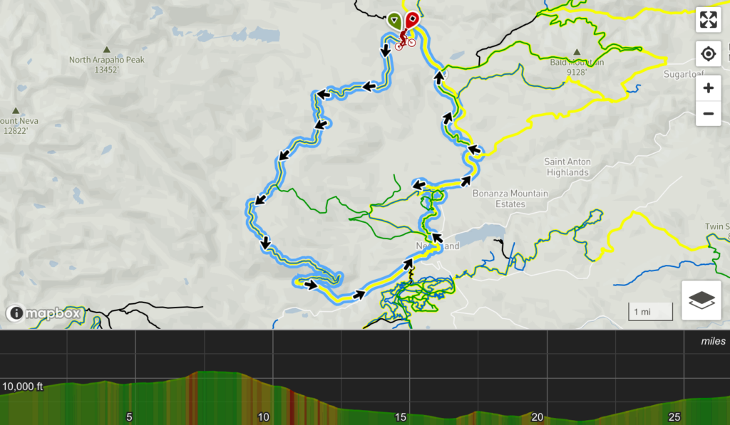
Distance: 26.7 Miles
Difficulty: Intermediate
Elevation Gain: 2,883 feet
Elevation Drop: 2,899 feet
Average Grade: 4%
Notes: Riders say you’ll enjoy this route as long you pick good lines and dig technical terrain. Jeff, on MTB Project calls it, “A diverse route that combines dirt road, gnarly gutted jeep road, smooth pavement.” You’ll also get roots and rocks and well, you’re in for a long day. If you want to read about the fight between mountain bikers up in Nederland, check out Outside Magazine’s article, “Colorado’s Singletrack Wars.”
Circumnavigation of Mt. Guyot
Distance: 38.5 Miles
Difficulty: Difficult
Elevation Gain: 5,204 feet
Elevation Drop: 5,312 feet
Average Grade: 5%
Notes: This is a favorite route for the Breck Epic, a 6-day mountain bike race in Breckenridge, Colorado. Fun fact: you’ll cross over the Continental Divide twice where you’ll max out at 12,033 feet. As we’ve mentioned before, all exposed routes are bound to get hit hard when a storm rolls in. You’re safest to start riding early and remember to bring enough food and hydration so you’re not calling for help halfway through. Check out the video above for some highlights of the trail.
South Saint Vrain Figure 8
South Saint Vrain – Figure 8 on Trailforks.comDistance: 16.3 Miles
Difficulty: Difficult
Elevation Gain: 2,072 feet
Elevation Drop: 2,086 feet
Average Grade: 5%
Notes: It’s an enjoyable, albeit muscle-building, lung-torching route, that has a great flow. If you really like super techy trails, this is the route for you. There are plenty of rock gardens throughout the route that’ll surely kick you around a bit. Peter on MTB Project says, “Not for the faint of heart, but hell of a ride. The climb up sourdough is super technical, expect slow pace and a bunch of time out of the saddle hoping over tons of rocks both large and small, loose and stationary.” Wear the pads and drop the ego.
Looking for more mountain biking content? If you’re curious about what it’s like to be a mountain bike instructor, check out our article with Josh Whitmore, owner and operator of MTB Skills Factory.


